






Top 5 Pink Lakes in the World You Need to See at Least Once


There's nothing photoshopped about a pink lake. Around the world, a small handful of extremely salty lakes and lagoons turn a startling shade of bubblegum, salmon or rose because of the microscopic life that thrives in them, mostly the algae Dunaliella salina and various pigmented halobacteria, which produce carotenoid pigments (the same beta-carotene family that colours carrots and flamingo feathers) as a kind of biological sunscreen once the water gets many times saltier than the sea. Some of these lakes sit in the middle of nowhere and take real effort to reach; others are a short drive from an international airport. Below are five of the most striking pink lakes on Earth, spanning Australia, West Africa, Mexico and Spain, including South Australia's underrated giant, Lake MacDonnell.
1. Lake Hillier, Western Australia
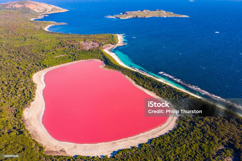
Lake Hillier is the lake that put pink lakes on the map. It sits on Middle Island, the largest of the roughly 105 islands and islets that make up the Recherche Archipelago, a wild, protected nature reserve strung along Western Australia's southern coastline. The lake itself is barely 600 metres long, but its colour is extraordinarily intense, and the setting is almost cinematic: a perfect oval of hot pink water fringed by white salt crust, dark green paperbark and eucalypt woodland, with just a narrow strip of sand separating it from the deep blue of the Southern Ocean. It was named after William Hillier, a crew member of the British explorer Matthew Flinders, who died on a neighbouring island during Flinders' 1802 survey of the coast.
For well over a century, nobody could definitively explain the colour. That changed in 2022, when researchers from the University of Vermont and the Australian genomics company Microbia ran DNA sequencing on water samples and identified more than 500 species of extremophiles living in the lake, including several strains of pigment-producing halobacteria and salt-loving bacteria such as Salinibacter ruber. The lake is roughly as salty as the Dead Sea, a condition almost nothing else can survive in, which is exactly why these microbes have the place to themselves.
Getting there takes real commitment. The gateway is the coastal town of Esperance, itself about 720 kilometres (roughly an 8-hour drive) southeast of Perth, or a 1-hour-40-minute flight. From Esperance, Middle Island lies around 120–150 kilometres further east, and there are no roads, ferries or facilities of any kind on the island: it's uninhabited and managed as an A-class nature reserve. Most visitors see Lake Hillier from a scenic flight (about 1 hour 40 minutes in the air, run by operators like Goldfields Air Services or Fly Esperance), circling the island for photos from both sides of the cabin. A small number of boat charters have historically run the roughly 2-hour crossing and allowed a guided beach walk on the island, though these trips are seasonal, weather-dependent and currently limited. It's worth knowing before you book: after a very wet year in 2022 diluted the lake's brine, Lake Hillier's colour faded to a paler blue-grey, and some tour operators have reported the boat trips paused altogether while conditions recover. Scientists expect the pink to return gradually as salinity rebuilds, but it's sensible to check current conditions with an operator before committing to (and paying for) a flight or cruise.
While you're in the area, Esperance has plenty to fill out a trip: Cape Le Grand National Park, about 50 kilometres east of town, is home to Lucky Bay, famous for squeaky white sand and kangaroos that genuinely lounge on the beach. Closer to town, the so-called "Pink Lake" (officially Lake Spencer), just 3 kilometres from Esperance, is easy to drive to, though be warned it hasn't actually been pink for over a decade, for similar reasons involving changed salinity from human activity nearby.
Drones Regulations Recreational drones are generally not permitted over Middle Island. It sits inside the Recherche Archipelago Nature Reserve, an IUCN "strict nature reserve," access is only via licensed tour operator, and the main way to see the lake is by scenic flight, so drones would conflict directly with tour aircraft in a shared airspace. Standard Australian CASA rules (under 120m altitude, clear of aircraft, visual line of sight) still apply anywhere else in the archipelago, but for Middle Island itself, plan to leave the drone at home and rely on your operator's aerial views instead.
What to wear: This is a boat or small plane trip with real wind chill, even on a hot day, so layers matter more than swimwear. For men: a light long-sleeve shirt or quarter-zip over a t-shirt, quick-dry shorts or pants, and closed-toe deck shoes or trainers for uneven salt crust and boat decks. For women: the same layered approach, a cropped jacket or light cardigan over a dress or top, flat closed shoes rather than sandals for shore walks. Cream, white or pale blue clothing photographs best against the bubblegum pink, since it reads as a clean contrast in photos rather than blending into the salt-crust background. A wide-brim hat with a chin strap is worth it given the wind, and a polarising sunglasses lens cuts glare off the water for both the view and your photos.
2. Lake Retba (Lac Rose), Senegal

Lake Retba, known locally in Wolof as Lac Rose, sits on the Cap-Vert peninsula roughly 30 to 40 kilometres northeast of Dakar, Senegal's capital, close enough to be a straightforward half-day or full-day trip by taxi or tour from the city. The lake is small, only about 3 square kilometres, and separated from the Atlantic Ocean by a thin band of dunes. Its salinity is exceptional even by pink-lake standards: around 300 grams of salt per litre, roughly ten times that of ordinary seawater, and in the dry season it can exceed even the Dead Sea. The colour comes from the same salt-loving microbes found elsewhere on this list, most vivid between November and June when evaporation concentrates the salt further; during the rainy season (July to October) the pink fades noticeably.
Lake Retba isn't just a photo stop: it's a working landscape. An estimated 1,000 people harvest salt from the lake by hand every day, wading in (protected from the caustic water by a thick coating of shea butter) and using long poles to break salt crystals loose from the lake bed before loading them into wooden pirogues. Between them, the lake's salt workers pull out roughly 24,000 tonnes of salt a year, more than 70% of which is exported across West Africa, mostly to Côte d'Ivoire. Visitors can watch this process up close, take a pirogue ride across the lake, or float in the hypersaline water themselves; the salinity makes swimming almost effortless, similar to the Dead Sea. Quad bike and 4x4 tours across the surrounding dunes are popular too, partly because Lake Retba has a claim to fame beyond its colour: for decades it was the finish line of the Paris–Dakar Rally.
Because it's so close to the capital, Lac Rose pairs easily with other Dakar-area highlights. Gorée Island, a UNESCO World Heritage site and a deeply significant location in the history of the Atlantic slave trade, is a short ferry ride from central Dakar. The Bandia Wildlife Reserve, home to giraffes, rhinos and antelope on a former hunting estate, is also commonly combined with a Lac Rose day trip from Dakar or the resort town of Saly further south.
Drones Regulations : As of early 2026, this is the strictest entry on the list. Senegal's civil aviation authority, ANACIM, has effectively closed recreational drone flying to typical foreign visitors under a recent security-driven policy: you'd need a pre-approved import permit and a separate flight authorisation from the Ministry of Interior, arranged before arrival, and the process is slow and rarely granted for tourism. Practically, bring your drone at your own risk of confiscation at customs, or skip it and shoot from the shore or a pirogue instead.
What to wear: Expect strong sun, dry-season heat, and dune walking, plus the option to float in the lake. For men: swim trunks under quick-dry shorts, a breathable short-sleeve shirt, and sandals with a back strap for the dunes and salt shore. For women: a swimsuit with a light kaftan or sarong as a cover-up when walking through the salt-collectors' area or nearby village, since modest dress is appreciated in local Senegalese communities away from the water itself. If you plan to float, note locals protect their skin with shea butter before entering the hypersaline water; bring your own or buy it locally rather than relying on sunscreen, which can sting in a cut or graze. A scarf or light headwrap doubles as sun protection on the exposed pirogue ride and works well for photos against the pink water and gold dunes.
3. Las Coloradas, Mexico
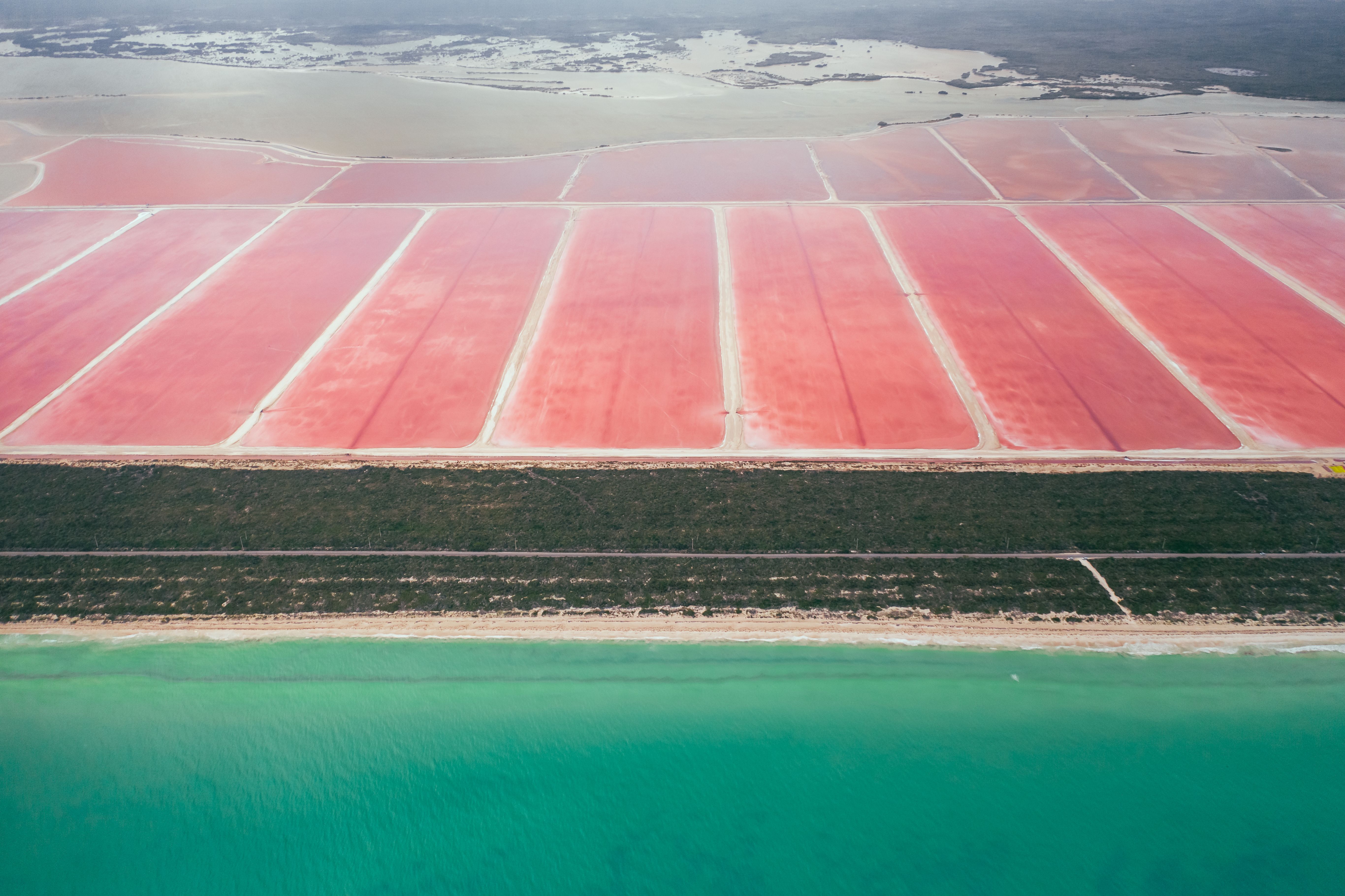
At the very northern tip of the Yucatán Peninsula, inside the Ría Lagartos Biosphere Reserve, Las Coloradas is a chain of shallow salt-evaporation ponds beside the tiny fishing village of the same name. Unlike some of the others on this list, these pools aren't a single natural lake but a series of man-made ponds used in an active industrial salt operation, though the underlying phenomenon is entirely natural. Seawater is pumped in and allowed to evaporate in stages, and as salinity climbs through each pond, the same microalgae and brine shrimp that colour Lake Retba and Lake Hillier bloom here too, turning the water everything from pale rose to an almost fuchsia pink. Salt has been harvested on this stretch of coast since the ancient Maya used it as a trade good on routes reaching deep into central Mexico; the modern, larger-scale operation still relies on the same basic principle of sun and wind doing the evaporating.
Las Coloradas is genuinely remote from Mexico's main tourist hubs. It's roughly 280 kilometres (about 3.5 hours' drive) from Cancún, and around 230 kilometres (roughly 3 hours) from Mérida, the closer of the two major cities. There's no direct public transport, so most visitors either hire a car or join an organised day tour from Mérida, Cancún, Valladolid or Playa del Carmen. Because the site sits on private salt-company land, casual wandering isn't an option: you visit as part of a small, paid guided tour (typically just a few US dollars for entry), with a guide keeping everyone on set paths between the working ponds. After the location went viral on social media a few years ago, swimming was banned outright in most areas to protect the fragile ecosystem, though a few tour operators now allow a brief, supervised float if arranged in advance. This changes seasonally, so it's worth confirming with your operator before you count on getting in the water. Drones are also prohibited following an incident, and touching the water or salt crystals is generally discouraged.
The pink ponds are only part of the appeal. The surrounding Ría Lagartos Biosphere Reserve is home to the largest flamingo colony in North America, and boat tours from the nearby village of Río Lagartos are the standard way to see thousands of the birds up close, feeding on the same brine shrimp that colour the lakes. Many visitors combine the trip with a stop in Valladolid, a handsome colonial town about two hours away that also gives access to cenotes and the Mayan ruins at Ek Balam, making Las Coloradas a natural fit for a longer Yucatán road trip rather than a rushed day out from the coast.
Drones Regulations: : Explicitly banned on site after a drone crashed into one of the ponds a few years ago, on top of Mexico's already restrictive national rules. Nationally, AFAC treats foreign visitors as barred from flying anything over 250 grams (registration requires Mexican ID), and sub-250g drones sit in an unenforced grey area at best. Combined with the site-specific ban, don't bring one out at Las Coloradas at all.
What to wear: This is a guided walk on narrow paths between working salt ponds in humid, high-glare heat, with no swimming allowed in most areas and strict rules against touching the water or salt. For men: a lightweight long-sleeve sun shirt (UPF-rated if you have one), quick-dry trousers or shorts, and closed-toe walking shoes or sturdy sandals, since the crusted salt edges can be sharp underfoot. For women: the same logic, a breathable long-sleeve top or sun hoodie over shorts or leggings, and shoes with a real sole rather than thin flip-flops. Long sleeves matter here specifically because guides ask visitors to skip heavy sunscreen and insect repellent near the water to protect the ecosystem, so covering up does the sun protection work that sunscreen normally would. A bright or white outfit again gives the strongest contrast against the pink and against the neighbouring turquoise and yellow ponds.
4. Lake MacDonnell, South Australia
.jpeg)
Fifteen kilometres south of the small township of Penong, on South Australia's remote western Eyre Peninsula, Lake MacDonnell is arguably the biggest and most dramatic pink lake in the Southern Hemisphere. It sits on the largest gypsum deposit south of the equator: an estimated 500 to 700 million tonnes spread across some 87 square kilometres, formed as gypsum and salt were deposited by natural solar evaporation of marine brines in a coastal dune depression during the Holocene period, tens of thousands of years ago. Gypsum has been commercially mined here since 1919, and salt is still extracted as a secondary product today.
What makes Lake MacDonnell so visually arresting is the causeway that runs straight through it, nicknamed "Watermelon Avenue" by locals. On one side sits the vivid pink salt lake; on the other, a striking teal-blue brine pond, the two colours separated by nothing more than a dirt road, producing one of the most shared travel photos in South Australia. As at the other lakes on this list, the pink comes from Dunaliella salina algae and carotenoid-producing bacteria, concentrated over decades by the site's ongoing salt and gypsum extraction.
Lake MacDonnell is remote, but not difficult to reach once you're in the region. The nearest town with real services (fuel, accommodation, an airport) is Ceduna, itself a very long way from anywhere: about 780 kilometres, or roughly 8 to 9 hours' drive, west of Adelaide along the Eyre Highway, or a short regional flight to Ceduna Airport. From Ceduna, it's about 74 kilometres west along the highway to Penong, then a further 13 to 15 kilometres down a well-graded gravel road (Point Sinclair Road) to reach the lake itself. No 4WD required, an ordinary car will manage it comfortably in dry conditions. Many travellers fold it into a longer Nullarbor crossing or a loop around the Eyre Peninsula.
It's well worth continuing a few more kilometres past the lake to the coast. Point Sinclair and Cactus Beach, about 3 to 4 kilometres further along the same road, is one of Australia's most famous surf breaks, with three distinct waves that draw serious surfers from around the country, plus a sheltered swimming spot and basic camping. Back in Penong itself, the "Windmill Town" of South Australia, more than a dozen preserved historic windmills are dotted around the township, a quirky reminder of how early settlers pumped water from this arid stretch of coast.
Drones Regulations: No lake-specific ban is published, so standard Australian CASA rules apply: fly under 120 metres, in daylight, in visual line of sight, and well clear of the small aerodromes at Penong and Ceduna. The practical catch is that Lake MacDonnell sits within an active gypsum and salt mining lease, private and operational land, so flying directly over the lake or any mine infrastructure without the leaseholder's permission is a landholder and safety issue even where aviation law alone wouldn't stop you. The safest approach is to fly (if at all) from the public gravel road or its shoulder, staying well clear of any mine buildings, stockpiles or machinery.
What to wear: This is remote outback terrain: full sun, wind, gravel, and salt crust, often with a further stop at Cactus Beach afterward. For men: a long-sleeve shirt or sun hoodie, cargo shorts or lightweight trousers, and closed hiking shoes or trail sandals rather than thongs, since salt crust and gypsum grit are rough on bare feet. For women: the same practical base, a breathable long-sleeve top or shirt-dress, and sturdy flat shoes; save sandals for the beach stop rather than the lake edge. A hat with a wide brim and genuinely good sunglasses are close to essential here, since there's no shade anywhere near the lake and the white salt and gypsum reflect glare hard. If you're continuing to Cactus Beach, pack swimwear separately so you're not stuck walking the gravel track in wet gear.
5. Torrevieja Pink Lake, Spain
On Spain's Costa Blanca, the Laguna Rosa de Torrevieja is by far the most accessible pink lake on this list: a genuine pink lake inside a protected nature park, right on the edge of a popular Mediterranean resort town, with over 320 sunny days a year to view it. It forms one half of the La Mata and Torrevieja Lagoons Natural Park, a protected wetland covering more than 1,400 hectares, paired with the neighbouring green-coloured Laguna de la Mata. The lake's salinity runs at around 350 grams per litre, roughly ten times saltier than the surrounding Mediterranean, which is what allows Dunaliella salina algae and Halobacterium bacteria to bloom and tint the water everything from pale grey-pink to a vivid magenta, typically most intense in summer, at sunset, and after dry spells.
Torrevieja itself is a well-established beach town of around 85,000 people, and getting there is straightforward: the nearest airport is Alicante–Elche (ALC), about 44 kilometres away, roughly a 40-to-50-minute drive or a little over an hour by the regular hourly bus service that runs directly between the airport and the town. Alicante city itself sits about 50 kilometres north up the coast. Because the lake is also an active industrial salt-extraction site, still producing hundreds of thousands of tonnes of salt a year, there's no free shoreline access; you view it from fenced perimeter paths (the panoramic spot at the end of Calle Sol is a local favourite), or go further in on the tourist train or a guided Salinas walking tour, which climbs one of the working salt mountains for a full view over the lagoon. The salt has been worked here for centuries, and the Museo del Mar y de la Sal in Torrevieja's harbour tells that history in detail, including the traditional salineros who harvested it by hand until well into the 20th century. As a bonus, up to 2,000 flamingos gather at the lake during breeding season, feeding on the same brine shrimp responsible for turning the water pink.
There's plenty to combine it with. The Palmeral d'Elx, a UNESCO World Heritage-listed palm grove and the largest of its kind in Europe, dating back to the Moorish period, sits about 30 kilometres away in the city of Elche. Guardamar del Segura, known for its pine-backed dunes and long beaches, lies just up the coast, and Alicante's hilltop Santa Bárbara Castle makes an easy add-on for anyone flying in or out of the airport.
Drones Regulations: : Governed nationally by AESA, and the lagoon sits inside a designated Natural Park (protected natural area), so recreational drone flights over the reserve itself need prior authorisation from the park's managing body on top of standard AESA operator registration, which is required for essentially any camera-equipped drone regardless of weight. In practice, most visitors don't get that authorisation for a short holiday visit, so plan to shoot from the marked perimeter paths, the tourist train, or the salt-mountain viewpoint instead of flying over the working lagoon.
What to wear: This is a resort town with an actively worked industrial site, viewed mostly from fenced paths or a short walking tour, so comfort and sun protection matter more than performance gear. For men: a linen or cotton short-sleeve shirt, shorts or light trousers, and comfortable closed trainers for the walk up the salt mountain viewpoint, since loose sandals can slip on compacted salt. For women: a breathable sundress or a top-and-shorts combination, with the same closed, grippy shoes for the salt-mountain climb rather than heels or thin sandals. Given how many day-trippers combine this with Torrevieja's beaches, it's worth packing swimwear separately in a bag rather than wearing it to the lake, since you can't swim there and beachwear alone won't cover you well on the exposed walking paths. Pale or pastel tones again give the cleanest contrast in photos against the pink water and white salt piles.